Thursday, March 3, 2011

Texas, San Antonio

Feb. 24

It is sunny and nice today in Texas.  We stayed around the campground today and in the afternoon went over and had ice cream in the rec hall.  We sat with the people camped next to us from British Columbia and met another couple from Missouri.  That is why we love traveling and staying in campgrounds.  We have met so many wonderful and friendly people along the way.  After dinner we went over to the music jam session in the rec hall.  People from this campground and other campgrounds nearby come and play music and sing.  We enjoyed the music.

Feb. 25

We are having another sunny and warm day.  After breakfast we drive into San Antonio and follow the Mission Trail along the San Antonio River.  This chain of missions were established along the river in the 1700's by Spain to extend its dominion northward from New Spain (present day Mexico).  Collectively they form the largest concentration of Catholic missions in North America.  These missions were first established in East Texas along the Rio Grande as way stations between these and other Franciscan missions in New Spain.  The friars transferred a failed mission to the San Antonio River in 1718 that is called the Alamo.  The other four missions were transferred  along the San Antonio River which helped form the foundation for the city of San Antonio.  American Indians living in the San Antonio missions came from several hunting and gathering bands know collectively as Coahuiltecans.  In exchange for labor and conversion to Catholicism, Indians received food and refuge in the missions.  These mission churches remain active centers of worship.  We also stopped by the Acequia System which was a 15 mile network of 5 dams and several aqueducts along the San Antonio River that irrigated about 3,500 acres of land.  We visited four of the missions today, Concepcion, San Jose, San Juan amd Espada and will visit the Alamo another day.  We had a great lunch at a Mexican restaurant along the mission trail.


Concepcion

Fireplace outside on the grounds of Mission San Jose


Dick walking by San Jose


San Juan


Espada


Alter in Espada


Acequia System

Feb. 26

There is a drizzle of rain falling this morning.  After breakfast we drive about 20 miles to the town of Bandera which is known as the cowboy capital of the world.  At noon there is a Marti Grau parade and many people are dressed to celebrate Marti Gras.   Got lots of beads that were thrown from the floats.  It was a fun parade were many different types of vehicles were decorated.  Had a great BBQ lunch at a local restaurant.  We walked up to 11th street where the gumbo cook-off was being held.  They were busy cooking all morning and now gumbo samples were being sold.  We were too full from lunch so didn't have room for gumbo.  Went to the 11th Street Cowboy Bar and listened to the live band.  There is an outdoor stage and area for sitting and dancing.  The place was full and we finally found a place to sit and have a beer and listing to the music.  There was a contest for the best Marti Grau costume.  It was a fun day.  When we got back to the campground they were having a BBQ dinner so we had brisket sandwiches and potato salad for dinner.  We stayed and listened to the jam session music for awhile.


Marti Gras parade in Bandera


Costume contest

Outdoor stage at Cowbow Bar


Feb. 27

Today it is sunny and hot.  There is no wind and we notice the humidity.  After lunch we go into San Antonio to a new flea market.  This market is very large and is built with concrete floor and separate garage like rooms for the vendors.  There are rides for the kids and food vendors also.  On each end a large covered area is for vendors to set up with tables.  We didn't buy anything but it was a good way to spend a Sunday afternoon. 

Feb. 28

Today it is my birthday so we go into San Antonio to the famous river walk.  The weather is sunny and not as warm as yesterday.  We first go to the Alamo and the grounds are beautiful with the giant live oak trees with the limbs almost touching the ground, red bud trees and flowers.  We spend some time just walking around the ground before going into the Shrine.  This year is the 175th anniversary of the Battle of the Alamo in 1836.  On Feb. 23, 1836, Santa Anna's army nearly caught the Texians and Tejanos by surprise.  The defenders held out for 13 days against Santa Anna's army.  William Travis, the commander of the Alamo, on the eighth day of the siege, asked for help from other communities in Texas.  A band of 32 volunteers arrived bringing the number of defenders to two hundred.  These men saw the Alamo as the key to the defense of Texas and were ready to give their lives rather than surrender their  position to General Santa Anna.  Among the Alamo's garrison were Jim Bowie and David Crockett.  The final assault came before daybreak on the morning of March 6, 1836, as columns of Mexican soldiers emerged  and headed for the Alamo's walls.  Cannon and small arms fire from inside the Alamo beat back several attacks.  The Mexicans finally scaled the walls and rushed into the compound.  They turned captured cannon on the Long Barrack and church, blasting open the barricaded doors.  By sunrise the battle had ended and Santa Anna surveyed his victory.  People worldwide continue to remember the Alamo as a heroic struggle against overwhelming odds where men made the ultimate sacrifice for freedom.  The Alamo remains hallowed ground and the Shrine of Texas Liberty. 
Next we walked down some steps to the river walk and enjoyed the many shops and great feel of the area.  Had lunch at one the the restaurants out on a patio along the river.  What a great place to spend my birthday!  We took a half hour boat ride around the river were our driver pointed out the buildings and facts about the river walk area.  Before leaving the river walk we stopped at a restaurant and had margaritas on the patio.  For my birthday dinner I chose Olive Garden where we had a very good dinner. 


Alamo


River Walk
Mar. 1

Sunny and nice again today.  We stayed around the campground and I did laundry in the afternoon. 

Mar. 2

We are enjoying another sunny day and after lunch go into San Antonio to the Mexican Market.  This is on the other side of downtown from the river walk.  It's two large buildings where booths are located and sell stuff from Mexico and South America.  I bought a small clay decorated sun and a bunch of corn husk flowers.  It was fun going through the shops.  It is too dangerous to go across the boarder into Mexico with the drug wars going on so this is a good alternative.  We stopped at Costco on the way back to the motor home.  For dinner tonight we drive to Bandera  to the 11th Street Cowboy Bar and they have a steak BBQ.  There are large BBQ's set up and you bring and cook you own steaks and they sell sides for $5.  We have a good time talking to people from all over the country and listening to the live music.  It was a great ending to a fun day. 

Steak night at the Cowboy Bar

Mar. 3

Cloudy in the morning but the sun came through before noon.  We are staying around the campground today so I can catch-up on my blog.  In the afternoon there is ice cream in the rec hall.  We met a couple from Everett WA at the rec hall today and are going to dinner with them tonight.  Definitely Happy Travels, Barb

Thursday, February 24, 2011

Texas

Feb. 11 through Feb. 18

We are in South Texas and the area is flat and we see lots of Mesquite trees, Live Oak trees and cattle.  I especially like seeing the Texas Longhorn cattle.   Jean has bird feeders in her yard that attract birds I have never seen before such as green jays and cardinals.  The land is vast and not populated.  There are small towns around the area and if you want a large town, San Antonio is only 70 miles away.  Pump Jacks are scattered in the area also.  New oil wells are being drilled as there is an oil boom going on here.  The campgrounds are full and more are being built.  They are mostly for the oil field workers.  Some companies are putting in campgrounds for their workers.  We did some exploring of the towns nearby and found some good restaurants.  We made one trip into San Antonio.  The weather has been warm but there is a wind blowing which makes it feel not so hot.


Pump jack


New well being drilled

Green jay

Cardinal


Feb. 19

After breakfast today we go to Aransas National Wildlife Refuge which is located on the Gulf of Mexico.  We spent about and hour and a half driving the refuge.  A tower at the end of the road gave us a great view of the gulf.  We saw a couple of alligators and birds but didn't see any cranes.  Aransas NWR has the largest flock of wintering whooping cranes in North America with over 250 birds.  By mid-April, they depart in pairs or small family groups for a hazardous journey 2,400 miles north to nesting grounds at Wood Buffalo National Park in Northwest Territories, Canada.  There was lots of wet lands in the reserve.  We drove into the town of Rockport and found a good seafood restaurant.  We had a good day seeing the Texas countryside. 


Smallest Alligator we have seen

Jones Lake where we saw the little gator


This is the closest I could come to a Crane


Feb. 20

We stayed around the campground today and Dick watched the Daytona 500 race on TV. 

Feb. 21

It's a sunny day today so we go down to Corpus Cristi.  As we enter the town we see oil refineries everywhere.  Each company has a refinery and they are enormous.  The tall chimneys can be seen in the skyline from quite a distance.  We cross the causeway to the town of Port Aransas.  This is located on an outer bank island of Padre Island.  At the end of the island is Padre Island National Seashore.  We have fish and chips for lunch before going to the seashore.  At the visitors center there is access to the beach along the gulf.  We take a walk on the sand but didn't find any sea shells.  Lots of people were enjoying the sunny day on the beach.  People can drive down the sea shore on the sand but four wheel drive is recommended after the first 5 miles.  There were motor homes and campers camping on the beach.  Several years ago we drove the entire 60 miles down Padre Island seashore with our friends, Bill and Jean.  We rented a four wheel drive car for the trip and it was quite a trip.  On the way back the tide was up and we had to drive partway at the edge and in the water.  Five of the world's seven sea turtle species have been documented nesting on Padre Island Nat. Seashore.  They work to protect the threatened or endangered sea turtles and from April through mid July, volunteers and staff search the beaches of Padre Island daily to detect and protect nesting sea turtles, eggs, and hatchlings. 

Refinery pretty at night with the lights

Oil refinery in Corpus Christi

On the beach on Padre Island


Feb. 22

It's raining in the morning when we get up but stops by 9.  Late in the morning we go into the town of Beeville to do laundry and have lunch.  There is a great market that smokes beef, chicken and sausage and also has a place to buy cooked food to eat there or take out.  Their prices are very reasonable and at lunch time the place is busy.  This is the second time we have lunch here.  We also buy some meat to take home. 


Sun setting over Texas

Feb. 23

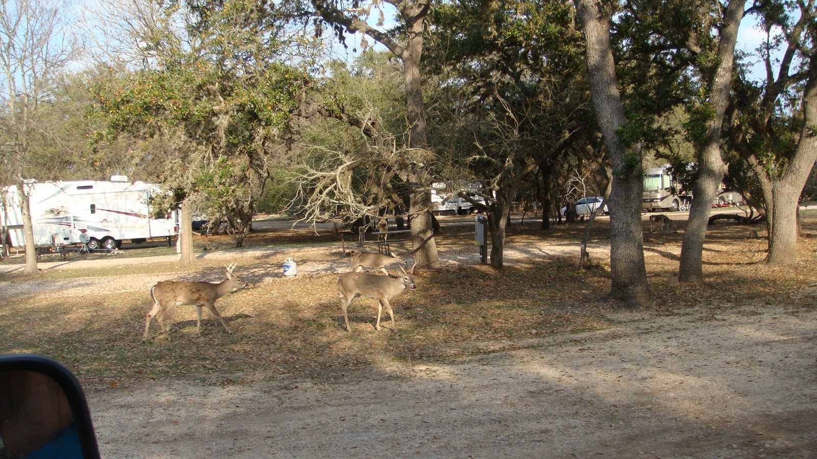
We have decided to move closer to San Antonio so today we leave the campground in Calliham and move to a campground west of San Antonio.  This is located in the hill country and on Medina Lake.  The road to the campground was very Windy.  This campground is full of deer.  I think there are more deer than people.  They are not afraid and just stand there and look at you and come right up to the camping rigs.  We plan on staying here for at least a week and maybe two.  Definitely Happy Travels, Barb


Deer in campground

Thursday, February 10, 2011

Mississippi, Louisiana and Texas

Feb. 2

Today we moved to Ocean Springs Mississippi and are camping at Davis Bayou on Gulf Island Nat. Seashore.  This campground is not on the water like the last one.  The seashore is on islands about 10 miles out in the Gulf.  There are boats that will take you there but not this time of the year.  You can go by private boat though.  We won't be visiting the islands.  When we were pulling into our campsite a news reporter and camera man approached us and asked it they can interview us about tourism in Mississippi.  I was on the news that night on WLOX out of Biloxi.  In the afternoon we visited the Mississippi Sandhill Crane National Wildlife Refuge and saw a short movie on the cranes.  The Mississippi sandhill cranes are a separate subspecies of sandhill crane and they do not migrate.  They were among the first species listed as "endangered" when the Endangered Species Act was enacted in 1973.  By the 60's the population of cranes was 30-35.  The refuge has restored habitat to its previous open savanna state to protect and restore an endangered species that began in 1975 with the creation of the refuge.  The cranes are long-lived birds that mate for life but rarely lay more than two eggs per year which makes population increases a slow process.  It was a cold and windy day so we did not see any cranes. 


Me on TV

Feb. 3

After breakfast we went towards Mobil to see another wildlife refuge.  This one didn't have a visitors center but had a large building where they did research.  We stopped and talked to a man there.  We ate lunch at a restaurant Dick had seen on Diners, Drive-ins and Dives called The Shack.  It was a very unique place and the BBQ was good. 

Feb. 4

Rain most of the day.  We stayed around the campground until late in the afternoon and went for a ride to Gulfport and back through Biloxi along the beach right along the gulf.  There are miles of no buildings along this part of the gulf because they were wiped out by Hurricane Katrina.  A few large hotels and casinos have rebuilt but the rebuilding is slow.  For dinner that night we saw on GPS there was a Olive Garden in Biloxi so we drove to find it.  There was a vacant lot where it once stood.  We ended up at the Beau Rivage Resort and Casino for their seafood buffet. 

Feb. 5

It's cloudy and cold today as we leave to go to New Orleans Louisiana.  Our campground is Pontchartrain Landing and is on the inner harbor navigation canal on Lake Pontchartrain.  This area was under 19 feet of water after Katrina.  The devastation from Katrina is evident everywhere we look.  Many houses are boarded up and abandoned and they can't tare them down because they can't find the owner.  These people were given anywhere from one hundred thousand to two hundred thousand dollars to rebuild but they took the money and left the area.  The population of New Orleans was one million  before Katrina and it is now three hundred and forty thousand.  Dick wanted to try crawfish so we found a grocery store that sold them already cooked.  The black woman who worked in the deli showed him how to clean and eat them.  The tails are pretty small so it would be hard to make a meal of them. 

Feb. 6

It's sunny and nice today as we get ready to go into the French Quarter.  Our campground has a bus to take us there and it only cost $5 each.  Our bus driver is a New Orleans police officer who works Bourbon St. in the Quarter.  He told us not to go out of the French Quarter were it is safe and only a few blocks away it is not.  Our first stop in at the famous Cafe Du Monde to have Beignets, French donuts, and coffee.  The line was halfway down the block but it didn't take long to get inside.  Beignets are piled high with powdered sugar and coffee, hot chocolate or juice are all they serve.  We walked along the streets and stopped in many of the shops.  Mardi Gras items were for sale everywhere.  The French Quarter lies along the Mississippi River so we walked to see it.  We had a good lunch of red fish with crawfish cream sauce.  There are people playing music, being statues, tap dancing, singing and anything to get people to put money in their bucket.  We took a buggy ride around the streets that was pulled by a mule.

Buggy rides


Man as a statue


Building with ornate balconies


Mississippi River by the French Quarter


French Quarter


Narrow streets


Dick and I have now been in every state except Hawaii.  On this trip we have been to 35 states so far, more to come on the way home.

Feb. 7

It was cloudy when we left this morning but blue sky poked through as we drove through Louisiana.  Early in the afternoon we get to our destination, Beaumont Texas.  The campground in nice and we get settled for the night.  Did some grocery shopping and went out to eat at a Mexican restaurant. 

Feb. 8

There is not a cloud in the sky as we leave the campground.  Today we head further into Texas.  The drive through Houston was not too bad.  There was lots of traffic but more going the other way.  We got great views of downtown Houston as we drove through on the freeway.  We arrived in Calliham Texas around three and got settled in our friends, Bill and Jean, campground.  We have known Bill and Jean since 2000 when they campground hosted at Laird Park in Idaho.  We have frown here to visit them several times and gone crappie fishing so we know the area.  Last year they put in a 18 site campground by their house.  There is an oil boom in south Texas and the campground is filled mostly with oil field workers.  We go out to dinner with them and have a nice visit.  We plan on staying here for a month so my blog will not have much traveling in it.  We are about 70 miles south on San Antonio on Choke Canyon Lake.  I can see the lake from my motor home window.  Choke Canyon is an enormous reservoir and has great fishing. 


Downtown Houston


Skyline of downtown Houston
Feb. 9

Dick and I took a little ride in the Jeep around the lake and he got a haircut in a nearby town.  The weather is very cold and a cold wind is blowing.  We didn't get the rain that was expected today but dark clouds hung around all day.  Cooked ribs for dinner and added side dishes and shared the ribs with Bill and Jean. 

Feb. 10

It was so cold in the night our water hose froze.  Got down in the 20's in the night and a cold wind was still blowing this morning.  We all drove to the town of Victoria and ate at a seafood restaurant and did a little grocery shopping.  It is going to be cold again tonight but will start warming up over the weekend.  Definitely Happy Travels, Barb

Tuesday, February 1, 2011

Okefenokee Swamp, Georgia, Alabama and Florida again

Jan. 23

We are camped in White Springs Florida which is a short drive to the Okefenokee Swamp across the border in Georgia.  This afternoon we drive to the west side of the swamp to Stephen Foster State Park.  There is a visitors center and boat basin to visit.  They are in a drought so there are no boat rides out of this area, only canoes can get out of the boat basin.  We walk a boardwalk out over the swamp and it is all dried up.  A short palm looking plant is everywhere in the swamp and woods and is a Sawtooth Palmetto.  We have seen this plant everywhere in Florida and now in Georgia.  Would like it see it when there is water.  Next we go to the Suwanee River Visitors Center which is located on the Suwanee River to see a short movie on the swamp.  A lot of places around here are named after Stephen Foster but only because he wrote the song about the river,  he never lived or visited the area. 


Entrance to the Okefenokee


Sawtooth Palmetto


Suwanee River

Jan. 24

It is sunny and nice today as we head to the east side of the swamp to the Suwanee Canal Recreation Area.  There is a visitors center and a boat basin with more water so there are boat rides through the swamp.  We take a 2:00 boat ride were we saw numerous alligators, shore birds, owls sitting in trees and even raccoon and otter.  Okefenokee is a vast bog of 402,000 acres, inside a huge saucer-shaped depression that was once part of the ocean floor.  Peat deposits up to 15 feet thick cover much of the swamp floor.  The slow-moving water are tea-colored due to the tunic acid released from decaying plants.  Our guide is a 5th generation swamp man and we had a very good trip through the swamp.  We stopped at an old homestead where the Chesser family settled on Chesser Island in 1850's.  The home we saw was built in 1927 by Tom Chesser.  Outbuildings include a smokehouse, syrup shed, chicken coop, corn crib and hog pen.


Spanish Moss covered tree


Alligators basking in the sun


Chesser Island Homestead
Cooking pot for syrup


Sugarcane Mill

Jan. 25

There is a light rain this morning as we move to Mexico Beach down on the gulf.  The campground is sand with puddles everywhere.  They had a down pour this morning.  After lunch we drive to the town of Apalachicola which is famous for Oysters and have a great seafood dinner.

Jan. 26

Sunny and nice again today as we take off back to Apalachicola where there is St. Vincent National Wildlife Reserve visitors center.  St. Vincent is on an island so we do not see the reserve.   There are a few displays in the visitors center but it is pretty small.  We go about 50 miles further east to St. Marks National Wildlife Reserve.  This is a better reserve with a 7 mile drive out to St. Marks Lighthouse, built in 1831.  The lighthouse isn't open to climb but is in good shape.  Along the road we see alligators and many shore birds.  On the way back to our campground we stop in Apalachicola at a seafood market and buy fresh oysters and shrimp.  That will be a good dinner. 


Jan. 27

Cloudy today as we leave to go further west to Gulf Shores Alabama.  The campground is not as nice as it looked on the Internet.  The area is full of restaurants and all kinds of shopping and definitely a snow bird destination.  We drive back into Florida in the Jeep to check out a National Park Service campground located on Gulf Islands National Seashore.  It is on the gulf by Pensacola Beach and we decide to move here on Saturday.


Road out to Gulf Islands National Seashore

Jan. 28

This is our last day in this campground so we decide to explore the area around here before moving back to Florida.  We start the day going to Bon Secour National Wildlife Refuge.  This is located on a finger of land with water on both sides, Mobile Bay and the Gulf of Mexico.  At the end is Fort Morgan and a ferry to the other side of Mobile Bay.  Homes and condos line the beach on both sides of this area.  It is hard to tell when we are in the refuge and we don't see any wildlife.  It was a nice ride out to the end of the road.  In 2004 Hurricane Ivan made landfall at Bon Secour National Wildlife Refuge as a category 3 hurricane.  It devastated communities from Dauphin Island, Alabama, to Pensacola, Florida.  We checked out Gulf State Park with 500 sites.  It is full now and with reservation full for the entire year.  They let people camp by the month for as long as they want.  All the recreation activities are in this campground, swimming pool, tennis, volleyball, golf course and boat launch.  People traveling through will never be able to get into this campground.  We drove to Orange Beach and Gulf Shores and high rise condos line the gulf shore.  We stopped at a public beach and walked on the sand and picked-up shells.  It's a beautiful beach and I see why it is so popular.  We pick-up some groceries and I did laundry before moving to the next campground. 


Offshore oil drilling platform in the Gulf


Condo at Orange Beach


Gulf Shores, Alabama beach


Jan. 29

The weather is sunny and nice today as we move to Fort Pickens Campground on Gulf Islands National Seashore.  We drive through Pensacola and over a long bridge to Gulf Breeze then over another bridge, this one with a toll, to Pensacola Beach.  I was surprised to see such a large town with beach houses,  large condos, restaurants and shops.  We drive out to the National Seashore through a gate with costs $8 but we are free with the senior pass.  Now all we see is white sand and water on both sides of the road.  The sand is so white in color that it looks like snow and the water is a beautiful blue green color.  The campground is large and there are lots of sites.  We have water and 50 amp elect. and it is only $10 a night with our senior pass.  This campground was destroyed by hurricane Ivan in 2004 and has only been reopened this year.  We will stay here for a few days.  The weather is going to be rainy off and on so we will wait out the weather before we move again.  Armadillos are in the campground and don't seem to mind people taking their picture.  After lunch we go to Fort Pickens at the end of the island.    Fort Pickens is the largest of four forts built to defend Pensacola Bay and its navy yard.  The fort was completed in 1834 and used until 1947.  It is constructed of over 21.5 million bricks and built by African-American slave labor.  The only real action the fort endured occurred during the Civil War.  Fort Pickens was one of four seacoast forts in the South that remained in Union control during the Civil War.


Armadillo


Fort Pickens


Jan. 30

Cloudy and rain is in the forecast.  After breakfast we drove into Pensacola Beach and drove east to the other end of the island.  Many beach houses and condos line the shore.  We came to another section of National Seashore and then to the town of Navarre where the road ends and  there is another bridge over to the mainland.  We see large pieces of asphalt scattered in the sand along the road.  The road on this island was destroyed by hurricane Ivan in 2004.  The eye came right over Orange Beach.  On the way back we stopped at some of the shops in Pensacola Beach.  We found a good seafood restaurant to have lunch before going back to the campground.  In the afternoon we did a little bike riding and went across the road to the beach.  There are crews working on the beach cleaning up the crude oil that is washing in on the beach after the oil spill of last spring.  The oil is dry to the touch and looks like little black rocks but you can make an indent with your fingernail or break it in half.  They walk along the beach with long sticks with a screen on the end to pick-up the oil.  They have sand carts that look like golf carts to carry the buckets and equipment.  The crew numbers about 20 and they are getting paid to do this.  They work 7 days a week and don't quit until dark.   The only thing is, oil is being washed up daily so their job will never be done.  I was at the beach the day after they had been through that section and found lots of large globs washing in the surf.  There is a machine called a sand shark that cleans the sand down a couple of feet but they don't seem to want to use it.  I don't  know who is paying the bill but I think the crews walking the beach is a huge waste of money.  The rain finally came late in the afternoon and it just pour during the night. 


Large piece of asphalt from the road before Hurricane Ivan


Jan. 31

The weather is nice today so we decide to go into Pensacola to the National Museum of Navel Aviation.  The museum is located on the Pensacola Naval Air Station so we had to show ID to get on the base.  What a great museum.  There were all kinds of military airplanes on display in two indoor buildings and many more outside which we rode on a trolley to see.  This is the home of the Blue Angels and there were several retired Blue Angel planes on display.  They practice Tuesday and Wednesdays the middle of March through the first week in November and it is open to the public.  They practice in California the rest of the year.  Their show schedule runs from March through November also.  Across the road is the Pensacola Lighthouse that we visit next.  We decide to climb the 177 steps to the top.  What a view from the top.  We can see the island where we are staying across the bay.  The lighthouse light is still in operation and we could see it as we went back to the campground that night.  There was also a museum and the keeper's house, which was attached to the tower, was furnished as it would have been when a family lived there.  This was a very interesting lighthouse to visit and we enjoyed our day in Pensacola.  We stopped for a seafood dinner on our way back to the motor home.  You probably think we eat way too much seafood but that would not be possible as Dick and I both love it. 


Blue Angel plane you can climb in cockpit


Blue Angel display


Feb. 1

The weather forecast was showing rain and wind so we stayed around the campground today.  The weather down along the gulf states of Louisiana, Mississippi and Alabama does not look good.  The bad weather should be through the area and further north  by morning so we plan on moving into Mississippi in the morning.  There is another campground in the Mississippi section of Gulf Islands Nat. Seashore located by Ocean Springs that we are going to move to tomorrow.  We will stay there for 3 nights until the next window of good weather.  Tonight I am making chicken noodle soup with the homemade noodles we bought in Amish area of Pennsylvania.  Good dinner for a rainy night.  We have been on the road for 5 months and traveled over 10,700 miles.  Definitely Happy Travels, Barb